Another powerful storm system could lash 70 million people from the South to the Upper Midwest – including states devastated by recent tornadoes.
The threat stretches from Texas all the way up to Michigan.
Parts of the central US could get strong to violent, long-track tornadoes Tuesday afternoon. And especially dangerous nighttime tornadoes could strike parts of Arkansas, Oklahoma and southern Missouri overnight – potentially causing more destruction in areas already pummeled by last week’s deadly tornadoes and storms that killed 32 people.
Tornadoes that strike in the middle of the night are often deadlier than twisters that hit during daytime hours because people are less likely to get weather alerts when they’re asleep, research shows.
“Please remain weather aware, have multiple ways to receive warnings & stay tuned to the forecast for updates,” Missouri State Emergency Management officials warned.
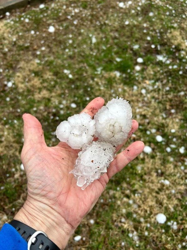
Baseball-sized hail fell
The storms will likely come in waves Tuesday and thrash Iowa, Illinois and Missouri with multiple rounds.
About 3 million people are under a tornado watch in parts of Illinois, Iowa and Missouri until 10 p.m. CT, according to the National Weather Service, bringing the threat of tornadoes, widespread large hail and wind gusts of up to 70 mph. The area includes cities like Des Moines and Cedar Rapids, Iowa, and Columbia, Missouri.
More than 23,000 homes and businesses were without power in Illinois as of 6 p.m. CT, according to utility tracker PowerOutage.us.
The first round of storms started in the afternoon, dropping very large to giant hail, according to the Storm Prediction Center. Davenport, Iowa, reported 4-inch hail – just larger than a softball – while Oswego and Aurora, both western suburbs of Chicago, saw baseball-sized and pool-ball-sized hail, respectively.
“Worst hail I’ve ever heard in Davenport,” Paul Schmidt wrote on Facebook, saying he worried about the condition of his home. “Sounded like bricks hitting the roof.”
West-central Iowa could get walloped by a trio of strong tornadoes, large hail and damaging winds.
There are two Level 4 of 5 risk areas Tuesday, the storm center said. A Level 4 risk means long-lived, “widespread and intense” storms are likely.
The first Level 4 area stretches across eastern Iowa, northwestern Illinois and northeastern Missouri. The second includes southern Missouri and parts of Arkansas and Oklahoma.
A new cluster of storms is likely to quickly become severe as it develops Tuesday afternoon into the early evening, starting in Missouri and Iowa and spreading into Illinois. Several tornadoes, some strong and long-track are possible, with these storms well after dark.
A Level 3 of 5 risk area includes St. Louis, Missouri; Madison, Wisconsin; Des Moines, Iowa; and Little Rock, Arkansas – which was ravaged by a violent tornado Friday.
A Level 3 risk means numerous severe storms are possible, and some may be intense.
“Weather conditions in these areas could be life-threatening at times, and those in affected areas should pay close attention to the local NWS Weather Forecast Office for Advisories, Watches, and Warnings,” the Weather Prediction Center warned.
More than 50 tornadoes touched down in several states Friday and Saturday, obliterating houses and leaving communities wondering how they’ll recover.
Blizzard conditions are expected to cause highway closures for days
South Dakota is facing a different kind of extreme weather. More than 140 miles of the Interstate 90 and about 85 miles of I-29 are closed indefinitely due to blizzard conditions, according to an alert on the state’s Department of Transportation website.
The closure affects I-90 from Rapid City to Murdo and I-29 from Watertown to the border with North Dakota, the tdepartment said.
“Accommodations at Murdo are limited. Adjust travel plans and seek shelter elsewhere. Expect multiple day closures,” the alert warned.
The NWS issued a blizzard warning and a winter weather advisory for the affected areas.
‘Extremely critical’ fire threat in the Southwest and Plains
More than 12 million people from southeastern Arizona to southeastern Nebraska are under red flag warnings Tuesday.
According to the NWS, a red flag warning are issued when warmer temperatures, low humidity, and strong winds are anticipated to combine to increase the risk of fire.
Fires could be fueled by dry surface air, breezy winds, dead grass and brush and warm temperatures,” the NWS office for Omaha and Valley, Nebraska, said.
An “extremely critical” Level 3 of 3 fire risk is in place across parts of eastern New Mexico, western Texas, western Oklahoma and southern Kansas. This area includes the Texas cities of Lubbock, Amarillo, Midland and Odessa; and the New Mexico city of Clovis.
2:35pm CDT #SPC Day2 #FireWX Extremely Critical: east-central new mexico across the tx/ok panhandles and northwest oklahoma and into southwest and south-central kansas https://t.co/LEoXKVkNcs pic.twitter.com/hsQOJFavYZ
— NWS Storm Prediction Center (@NWSSPC) April 3, 2023
“Dangerous fire weather conditions are expected on Tuesday with potential for multiple large, dangerous, and fast moving fires,” the NWS said. “Extreme caution should be used to avoid sparks and open flames.”
A broader Level 2 “critical” risk encompasses the Level 3 area and extends from the Texas-Mexico border to southwestern Iowa, including Oklahoma City and Norman in Oklahoma, Wichita in Kansas, and Abilene and Wichita Falls in Texas.

